Live in Hyde Park
An 1880s streetcar suburb behind the longest continuous sidewalk in the country, and the neighbourhood that makes the fifty per cent rule concrete.
Hyde Park is the address South Tampa is measured against. It was laid out from the 1880s as Tampa's first streetcar suburb, filled in with bungalows and larger houses through the 1920s, and listed on the National Register as a historic district. The largest concentration of pre-war residential architecture in the city. Behind it runs Bayshore Boulevard, four and a half miles of balustraded seawall and what is generally described as the longest continuous sidewalk of its kind in the United States. That seawall is also the point. Hurricane Idalia put water over it in 2023 without making landfall anywhere near Tampa, and Helene did far more in 2024. The neighbourhood's reference point measures 20.3 feet above sea level, which sounds comfortable and conceals a steep gradient: the blocks against the water are a different proposition from the blocks four streets back. For anything near the bay the governing document is not the listing but the elevation certificate, and behind it the federal fifty per cent rule. Damage or improvement beyond half a structure's value forces it up to current elevation standards, which on a low pre-war house can cost more than the house is worth.
The best address in Tampa, on the wrong side of a seawall
South-west of downtown across the Hillsborough, bounded by Bayshore Boulevard and the bay on the south-east, Kennedy Boulevard on the north, and running west toward Howard Avenue and the rest of South Tampa.
Hyde Park is what Tampa built when its first streetcar line crossed to the peninsula in 1886. Bungalows, foursquares and larger houses filled it in through the 1900s and 1920s, and it became the address for the city's professional families, which, a century later, it still is. It is listed on the National Register as a historic district and holds the largest concentration of pre-war residential architecture in the city.
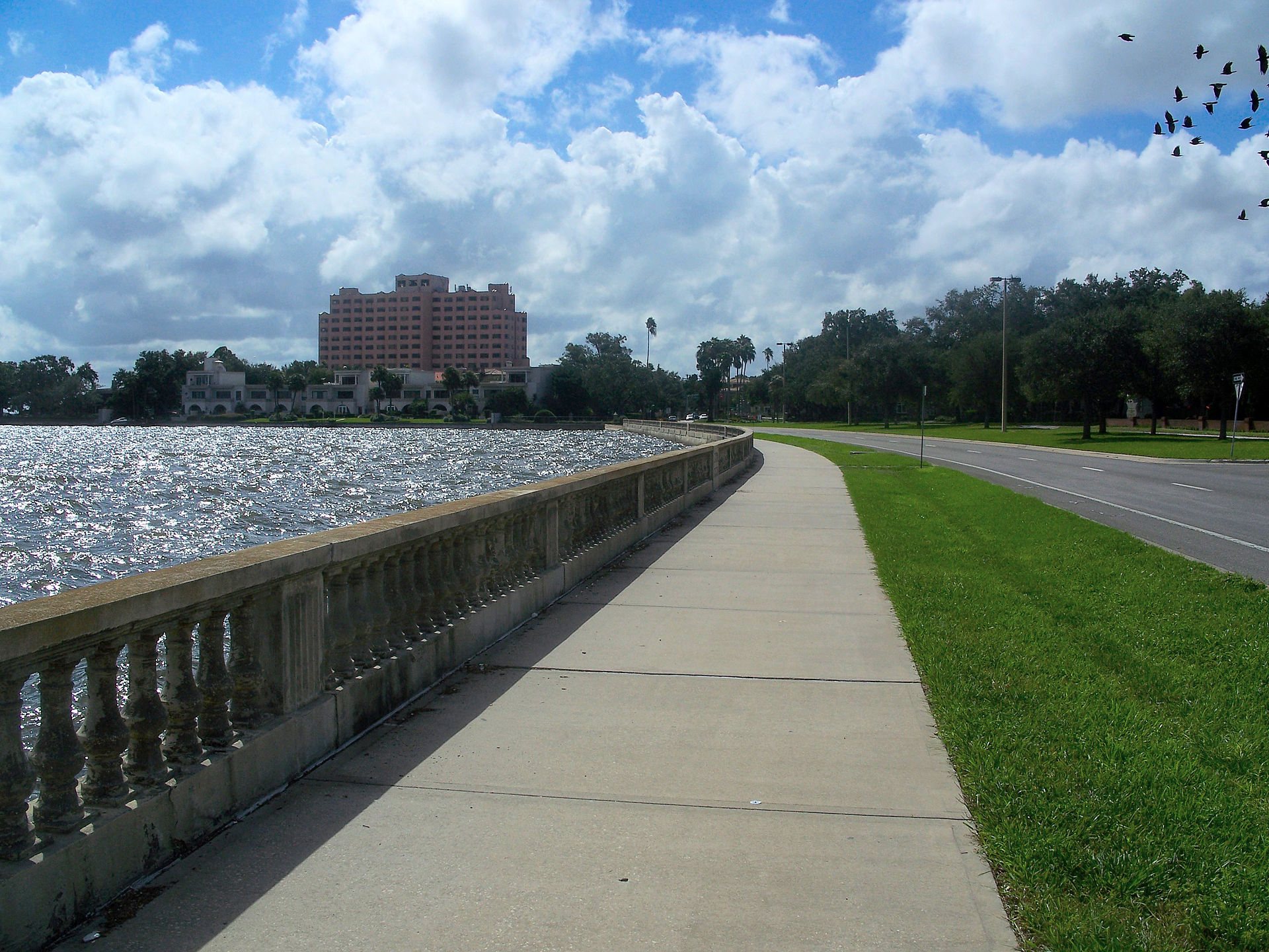
Behind it runs Bayshore Boulevard, four and a half miles of balustraded seawall and what is generally described as the longest continuous sidewalk of its kind in the country. It is the reason people move here and the reason to read the rest of this page carefully.
The seawall is the point. Hurricane Idalia put water over it in 2023 while making landfall in the Big Bend more than two hundred kilometres north; Helene did considerably more in 2024. The neighbourhood's reference point measures 20.3 feet above sea level, which sounds comfortable and conceals a steep gradient: the blocks against the water are a different proposition from the blocks four streets back, and a single figure for the neighbourhood is close to meaningless here.
What that means in practice is a federal rule with teeth. A structure damaged, or improved, beyond fifty per cent of its value must be brought up to current elevation standards, which on a low pre-war house near the bay routinely costs more than the house is worth, and turns a renovation into a teardown. If you are buying anything near the water here, the elevation certificate, the claims history and any substantial damage determination are the first three documents, ahead of the survey and well ahead of anything on the Tampa hub.

- Get the elevation certificate for the specific property, not a figure for the neighbourhood
- Ask for the claims history and any substantial damage determination from 2023 and 2024
- The fifty per cent rule decides whether a damaged pre-war house is a renovation or a teardown. Establish the structure's value basis before you plan work
- Flood is a separate policy from the homeowners figure on the Tampa hub, and near Bayshore it is not optional
- National Register listing recognises significance and does not by itself restrict a private owner, but check for any local district overlay, which does
- Gorrie and Plant catchments are priced into the houses inside them; confirm the address rather than the neighbourhood
How Hyde Park got here
- 1886Tampa's first streetcar line crosses to the peninsula, and development of the neighbourhood begins on land subdivided from the 1880s.
- 1900sThe area fills in with bungalows, foursquares and larger houses, and becomes the address for Tampa's professional and merchant families.
- 1920sBayshore Boulevard is built out along the bay with its balustrade, seawall and continuous sidewalk.
- 1985Hurricane Elena passes offshore and pushes water over the Bayshore seawall. The first modern demonstration that landfall is not required to flood this shoreline.
- 1980sThe Hyde Park historic districts are listed on the National Register, recognising the concentration of pre-war residential architecture.
- 2023Hurricane Idalia, making landfall in the Big Bend more than two hundred kilometres north, puts surge over Bayshore Boulevard.
- 2024Helene in September and Milton in October bring the largest storm surge on the bay's record. The repricing of low-lying South Tampa begins in earnest.

Bayshore Boulevard, and the islands off it
Hyde Park's open space is linear and on the water. Bayshore Boulevard is the neighbourhood's front yard, its running route and its social spine, and it does more work than any park in the city. For grass and a pool, Davis Islands (the 1920s dredged islands off the peninsula) carry a beach, a marina, playing fields and the region's trauma centre. Across the river, the Tampa Riverwalk and Curtis Hixon Waterfront Park are a short drive.

The resident's angle: the seawall is the amenity and the exposure at once, and living here means holding both ideas. It is also worth walking it at a king tide rather than on a still February morning, because the two experiences are not the same neighbourhood.
18 places, with real drive times
Road-adjusted distance and drive time from the centre of the community to each destination, nearest first. Filter by category.
Showing 1–12 of 18 places, nearest first.
Method: distances and drive times are computed from a representative point in the neighbourhood, using straight-line distance multiplied by a road factor and a tiered speed model: honest ranges, not routed times. Bayshore Boulevard is a corridor rather than a point, so its distance is hand-estimated, as this site's methodology does for every linear destination.
Every gym within reach
The neighbourhood needs less built provision than most because of what it has instead: four and a half miles of flat, continuous, lit seawall sidewalk. Beyond that, Davis Islands carries the nearest municipal pool and playing fields, and the private studio market in and around Hyde Park Village is substantial.
- Flat, lit and continuous for four and a half miles: the neighbourhood's actual exercise infrastructure
- Davis Islands has the nearest public pool, beach and playing fields
- Studio pricing rather than gym pricing around Hyde Park Village
- Busiest at dawn and dusk; the middle of a summer day is not usable
| Facility | What it is | Drive |
|---|---|---|
| Bayshore Boulevard open | Not a gym: the seawall sidewalk is the neighbourhood's actual exercise infrastructure, and the reason it needs less of the built kind. | 6–9 min |
| Davis Islands open | The islands off the peninsula carry a public pool, a beach and open ground, and are the nearest municipal recreation. | 5–8 min |
The free option is the obvious one, and it is genuinely the best in the city, but check the tide table in September before planning a route along the low end.
The catchments are in the price
Most Hyde Park addresses are assigned to Gorrie Elementary, then Wilson Middle and Plant High: a sequence that is among the most sought-after in Hillsborough County and is straightforwardly capitalised into what houses sell for inside it. Hillsborough also runs magnet, career and International Baccalaureate programmes county-wide, and South Tampa has an unusually large independent sector alongside.
| School | Board | Note |
|---|---|---|
| Gorrie Elementary School | Hillsborough County Public Schools | The neighbourhood public elementary, and one of the most sought-after in the county, which is priced into the houses in its catchment. Hillsborough assigns by address; check the specific address. |
| Wilson Middle School | Hillsborough County Public Schools | The assigned middle school for much of South Tampa. |
| Plant High School | Hillsborough County Public Schools | The assigned high school for much of South Tampa, on the river at the neighbourhood's edge. Its catchment is one of the most closely watched boundaries in the county. |
| Hillsborough's choice programme | Hillsborough County Public Schools | Magnet, career and choice programmes run county-wide alongside assignment. Apply in the district's window if the magnet route matters to you. |
| Independent schools | Independent | South Tampa has an unusually large independent sector for a city this size, including several long-established day schools within a short drive. |
Because the catchment premium here is real, the boundary is the thing to verify rather than assume. Check the specific address in the district's boundary lookup before you pay for a catchment: Hillsborough reviews attendance boundaries, and a street can move.
Month by month, what living here looks like
Not a highlights reel: the actual annual rhythm, including the dates residents have to remember.
- Highs around 22 °C and lows in the low teens: the driest, mildest stretch of the year
- Peak season for visitors and for the bay
- The Bayshore sidewalk is at its busiest and its best
- The Gasparilla pirate invasion and parade take over the waterfront and much of the centre
- Still dry, still mild, and the best month for anything outdoors
- Street closures around the bay for a week or more
- Warming into the high twenties; humidity returns late in the month
- Spring training baseball across the bay area
- Strawberry season in Plant City, thirty-five kilometres east
- Warm, still mostly dry, and the last month before the air changes
- Insurance renewals cluster before hurricane season: get quotes now, not in June
- On anything near the water, the elevation certificate is the document that decides your premium
- The rainy season begins, usually in the second half
- Afternoon thunderstorms become a daily fixture rather than an event
- Tampa Bay is among the most lightning-prone places in the United States
- Atlantic hurricane season runs 1 June to 30 November
- Daily storms and high thirties with humidity
- Check the seawall, the drainage and the flood policy renewal date
- The hottest and one of the wettest months
- Outdoor life moves to early morning and after dark
- Lowest rates of the year on short leases
- Peak humidity and the start of the serious part of hurricane season
- King tides show on the low Bayshore blocks even without a storm
- Quietest month for restaurants and the easiest to get a table
- Statistically the peak of Atlantic hurricane activity, and the month Helene came in 2024
- Binding restrictions mean you often cannot buy a new policy with a named storm in the Gulf
- Ask what the specific block did in Idalia in 2023 and in Helene in 2024, not just at landfall
- The rains taper off and the humidity finally breaks
- Still hurricane season: Milton arrived in October 2024, two weeks after Helene
- The best month for the bay once the season is quiet
- Hurricane season ends on 30 November and the dry season starts
- Comfortable enough to be outside all day again
- Snowbird traffic returns and the bay gets busier
- Warm days, cool evenings and almost no rain
- Peak season proper begins
- The pay-off for August
20 photographs of Tampa and the region
Drawn from the site's shared, freely licensed Tampa photo library, not photographs of Hyde Park itself. Filter by category.


Showing 1–12 of 20 photographs.
About these photographs. Openly licensed images geotagged in or near Hyde Park, found on Wikimedia Commons and served from there with full attribution. Inline photos elsewhere on the page may still come from the site's shared Tampa library.