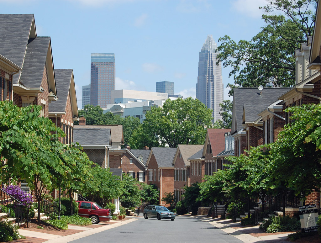
Live in Dilworth
Charlotte's first streetcar suburb, 1891 — bungalows under willow oaks, a local historic district with real design review, and the hospital campus at the end of the street.
Dilworth is where Charlotte learned to build neighborhoods. In 1890 Edward Dilworth Latta bought 442 acres of farmland and fairgrounds south of the city; on 18 May 1891 the electric streetcar started running out to it, and two days later the lots went on sale. That sequence — transit first, houses second — is the template every other early Charlotte suburb copied, and it is exactly what South End and the Blue Line did again a century later. The original grid mirrors uptown's wards; the curving streets at the southern end came later, in 1911, when Latta hired the Olmsted firm to lay out the extension. What survives is a full inventory of bungalows, four-squares and Queen Annes on real lots ten minutes from the centre, protected since 1983 by a local historic district that actually has teeth. It is expensive, it is leafy, and it has a Level I trauma centre at one end and a light rail corridor at the other.
Transit first, houses second — the template Charlotte has now used twice
South of I-277 between South Boulevard and the Little Sugar Creek corridor, running down to Freedom Park and the hospital campus on Blythe Boulevard. East Boulevard is the main street through the middle; the light rail and South End are on the western side, Midtown and the greenway on the eastern.
The sequence is the interesting part. Edward Dilworth Latta bought 442 acres of farmland and old fairgrounds in 1890; the electric streetcar started running out to it on 18 May 1891; the lots went on sale two days later. He built Latta Park at the end of the line — a dance pavilion, a boating pond, a ferris wheel — for the specific purpose of giving people a reason to ride out at weekends and see the lots. A century later Charlotte did precisely the same thing with the Blue Line and South End, two streets to the west.
Two street patterns, twenty years apart. The northern half is a grid that mirrors uptown's wards. The southern half curves, because Latta hired the Olmsted Brothers firm in 1911 to lay out the extension. Walking from one into the other is the clearest lesson in American suburb design available in this city, and it is also why the two halves feel different to live in.
What is inside the walk. East Boulevard, the main street, with restaurants and shops along it. Latta Park in the middle and Freedom Park — ninety-eight acres, the lake, the bandshell and the Nature Museum — at the southern end. The Little Sugar Creek Greenway along the eastern boundary, which reaches uptown in one direction and the wider trail network in the other. A Blue Line station and the whole of South End on the western edge. And Atrium Health Carolinas Medical Center, the region's Level I trauma centre, at the bottom of the neighborhood.
The honest version. The local historic district designation from 1983 is the single most important practical fact about owning here, and it cuts both ways: exterior alterations, additions and demolitions go to the Historic District Commission, which is why the streetscape survived the teardown wave that reshaped comparable neighborhoods, and it is also why your window replacement is a public hearing. The stock is 1900s to 1930s, so budget for knock-and-tube wiring, cast-iron drains, and attics that were never insulated for a Carolina summer. The hospital is an employer, an ambulance route and a shift-change traffic pattern all at once. And on the eastern side, check the Little Sugar Creek flood map for the specific parcel — this creek floods, and the greenway that makes those blocks desirable exists partly because the land beside it should not be built on.

- Inside the local historic district, exterior changes, additions and demolition go through the Historic District Commission — read its guidelines before you buy a house you intend to change
- The district boundary is not the neighborhood boundary; blocks just outside it are being torn down and rebuilt at three times the size
- 1900s–1930s stock: wiring, drains, attic insulation and window condition are the four things to price into an offer
- Little Sugar Creek floods — check the flood map for the parcel, not the street
- The hospital campus shapes the southern end: ambulance routes, shift-change traffic and a strong rental market for medical staff
- Mecklenburg revalues 1 January 2027, and Dilworth is one of the areas whose sale prices have run well ahead of its 2023 assessments
How Dilworth got here
- 1890Edward Dilworth Latta's Charlotte Consolidated Construction Company buys 442 acres of farmland and the old fairgrounds south of the city limits.
- 1891Charlotte's electric streetcar begins running on 18 May; Dilworth opens for sale on 20 May. Latta builds Latta Park at the end of the line — a dance pavilion, a boating pond and a ferris wheel — specifically to give people a reason to ride out at weekends.
- 1900sThe grid fills with bungalows, four-squares and Queen Anne houses, and East Boulevard becomes the commercial street. Mill housing goes up on the western edge toward the Atherton Mill.
- 1911Latta hires the Olmsted Brothers firm to lay out the southern extension, which is why the streets below Ideal Way curve while the older half is a grid.
- 1940sCharlotte Memorial Hospital opens on Blythe Boulevard at the southern edge. It is now Atrium Health Carolinas Medical Center, the region's Level I trauma centre, and it shapes the traffic, the rental market and a good deal of the neighborhood's employment.
- 1960s–1970sInterstate 277 is cut across the northern edge, severing the neighborhood from uptown, and the older housing stock falls out of fashion. Several blocks are lost to apartment redevelopment before anyone organizes against it.
- 1983Dilworth is designated a local historic district, which subjects exterior alterations, additions and demolitions to review by the Historic District Commission. The National Register listing follows in 1987.
- 2007The Blue Line opens along the western boundary, and the warehouse district on the other side of South Boulevard becomes South End. Dilworth's prices move with it.
- 2010s–2020sTeardown pressure arrives in full. Inside the historic district the commission constrains what can be built; on the blocks just outside it, 1920s houses are regularly replaced by houses three times the size, which is the clearest visible line the designation draws.

The green space here predates the houses
Latta Park came first — it was built in 1891 as the attraction at the end of the streetcar line, complete with a boating pond and a ferris wheel, and what survives is a shaded neighborhood park with tennis courts and a playground. Freedom Park, ninety-eight acres at the southern end, is the city's de facto central park: the lake, the bandshell, the playing fields and the Charlotte Nature Museum. Between and beyond them runs the Little Sugar Creek Greenway, the spine of Mecklenburg's trail network, on a creek that spent decades culverted under parking lots.
The resident's angle: the greenway is the reason this neighborhood works without a car for anything except commuting — it reaches uptown north and the Metropolitan and Freedom Park south, all off-road. The same creek is the flood risk. Look at the FEMA map and the county's own floodplain layer for any address on the eastern blocks, and treat a finished basement near the creek with suspicion.
19 places, with real drive times
Road-adjusted distance and drive time from the centre of the community to each destination, nearest first. Filter by category.
Showing 1–12 of 19 places, nearest first.
Method: distances and drive times are computed from a representative point near East Boulevard and Dilworth Road, using straight-line distance multiplied by a road factor and a tiered speed model — honest ranges, not routed times. Two caveats specific to here: the hospital's shift changes and the school run overlap between 7.30 and 8.30, and the I-277 crossings into uptown are the bottleneck at every hour.
Every gym within reach
The Dowd YMCA sits at the northern end of the neighborhood on East Morehead — a full-size pool, a large weight floor and the best value within a mile in any direction. Beyond it the options are the boutique studios along East Boulevard and in South End, and the greenway, which is what most of the neighborhood actually uses.
- Full-size pool and a large weight floor, a short walk or a three-minute drive from most of the grid
- Boutique studios cluster on East Boulevard and across South Boulevard in South End
- The Little Sugar Creek Greenway is the free option and runs the length of the eastern boundary
- Freedom Park has courts, fields and a loop most of the neighborhood runs in the evening
| Facility | What it is | Drive |
|---|---|---|
| Dowd YMCA open | 400 East Morehead, at the northern end of the neighborhood — a full-size pool, a large weight floor and family rates that undercut everything commercial nearby. | 3–4 min |
| Little Sugar Creek Greenway open | The free option: a continuous paved greenway along the eastern boundary running from uptown to Freedom Park and beyond, and the route most of the neighborhood runs on. | — |
The free option is the greenway plus Freedom Park: an off-road loop that reaches uptown in one direction and the Metropolitan and the park in the other, without crossing a road you have to wait at.
One elementary on two campuses
Dilworth Elementary runs on two campuses — the Latta campus inside the neighborhood and the Sedgefield campus to the southwest — and which one a child attends depends on the address and the grade. From there the usual path is Sedgefield Middle and Myers Park High, a 3,300-student school with the county's largest International Baccalaureate programme. Charlotte Catholic High School three miles south is the most common private alternative in this part of the city.
| School | Board | Note |
|---|---|---|
| Dilworth Elementary School | CMS | The neighborhood elementary, on two campuses — Latta in Dilworth and Sedgefield to the southwest. Which campus a child attends depends on the address and on the grade. |
| Sedgefield Middle School | CMS | The usual middle assignment for Dilworth, on Dorchester Place about a mile southwest. |
| Myers Park High School | CMS | A 3,300-student comprehensive high school two miles southeast, with the county's largest International Baccalaureate programme. |
| Charlotte Catholic High School | Diocese of Charlotte | The main Catholic secondary for the region, three miles south — the most common private alternative for families in this part of the city. |
| Central Piedmont Community College | Post-secondary | The main campus is on the eastern edge of uptown, two miles north, with trades, nursing and university transfer programmes. |
Charlotte-Mecklenburg Schools assigns by address, not by neighborhood, and the district has a magnet and assignment review under way that is expected to change options from 2027. Check the specific address in the CMS assignment lookup before you commit, and ask which campus of Dilworth Elementary the address feeds — that detail is missing from most listings.
Month by month, what living here looks like
Not a highlights reel — the actual annual rhythm, including the dates residents have to remember.
- Highs around 10 °C, lows near freezing, and the willow oaks bare enough to see the houses properly
- The quietest month for listings — anything on the market in January has usually been there since autumn
- An inch or two of snow in an average year, and the hills on the curving streets become genuinely tricky
- The wettest stretch of winter; Little Sugar Creek runs high and the greenway sections closest to it can flood
- Historic District Commission agendas are worth watching if you are buying — they show what the neighborhood is arguing about
- The hospital campus is at its busiest, which shows up in the evening traffic on Kings and East Boulevard
- Everything blooms at once; the Piedmont pollen count is genuinely notable and coats every porch yellow
- East Boulevard's patios reopen and the neighborhood becomes visibly busier
- Listing season starts; Dilworth stock turns over fastest in spring
- Mid-20s and dry — the four weeks that explain why people pay the premium for these streets
- Freedom Park's playing fields and the Nature Museum are at capacity every weekend
- Peak open-house season, and the point at which competition for a renovated bungalow is fiercest
- The canopy closes in and drops the street temperature noticeably against the newer neighborhoods
- Humidity arrives in the last week and stays until late September
- Race weekend traffic at the end of the month, mostly on the interstates rather than here
- Highs above 30 °C with sharp afternoon thunderstorms; mature trees over old houses means limb damage is a real annual risk
- Freedom Park's summer concerts start and the bandshell end fills up
- Check your gutters and your tree cover before storm season, not after
- The hottest month, and the one where a 1920s house's cooling performance shows — ask about attic insulation and duct work
- Fourth of July fireworks uptown are visible from the northern blocks
- The greenway is the only comfortable outdoor route between noon and five
- Schools return in late August, and the morning traffic on East Boulevard doubles
- The slowest month of the housing market, and the best month to negotiate
- Hospital shift changes and school runs overlap; the 7.30 to 8.30 window is the neighborhood's worst
- Remnants of Atlantic hurricanes reach the Piedmont as rain — Helene in 2024 was the reminder that inland is not immune
- Little Sugar Creek is the flood risk to check on any address near the eastern boundary
- Panthers Sundays add stadium traffic to the northern edge
- Dry, mid-20s and the busiest month on the greenway
- Home tours and neighborhood events run through the month; the Dilworth home tour is the one to look for
- Peak leaf colour is early November here rather than October
- The canopy turns and then drops, which is a genuine amount of yard work on a large lot
- Listings thin out and negotiation gets easier
- Thanksgiving quiets the neighborhood for four days
- The houses on the curving southern streets are the ones people drive in to see
- Highs around 12 °C — mild by any northern standard
- The last window to close before 1 January, which matters more than usual before the 2027 revaluation
20 photographs of Charlotte and the region
Drawn from the site's shared, freely licensed Charlotte photo library — not photographs of Dilworth itself. Filter by category.


Showing 1–12 of 20 photographs.
About these photographs. Openly licensed images geotagged in or near Dilworth, found on Wikimedia Commons and served from there with full attribution. Inline photos elsewhere on the page may still come from the site's shared Charlotte library.