
Live in Cotswold
Postwar ranch houses on quarter-acre lots inside Route 4, being replaced one at a time — the clearest teardown market in Charlotte, with a paired elementary school that is a deliberate experiment.
Cotswold is what Charlotte built in the 1950s and 1960s: brick ranch houses on generous lots, laid out around a shopping centre at Randolph Road and Sharon Amity, four miles from uptown and inside Route 4, the inner ring road. For forty years it was unremarkable and affordable. What it is now is the most legible teardown market in the city — the lots are big, the location is central, and a 1,500-square-foot ranch is worth less than the land under it, which means the streetscape changes house by house rather than block by block. The thing that makes it worth understanding beyond the price is the elementary school is a paired one: Billingsville and Cotswold were joined into a single two-campus school in 2018 as a deliberate attempt at integration, and it is one of the more interesting things Charlotte-Mecklenburg Schools has done in thirty years.
The most legible teardown market in the city
Around Randolph Road and Sharon Amity, east of Myers Park and inside Route 4, with Briar Creek running through it. Grier Heights and Billingsville sit west, Oakhurst and the Monroe Road corridor south, and Sardis Woods and the Route 4 ring beyond the eastern edge.
Cotswold is Charlotte's postwar suburb in its purest form: brick ranch houses on quarter-acre lots, built in the 1950s and 1960s on farmland east of Myers Park, arranged around a shopping centre at Randolph Road and Sharon Amity. It sits inside Route 4 — the inner ring stitched together from Woodlawn, Runnymede, Wendover and Eastway — five and a half miles from uptown, and it does not require an interstate to get anywhere.
What that location does to the houses is the whole story. The land is worth more than most of the buildings on it, so the neighborhood turns over one lot at a time: a 1,500-square-foot ranch comes down and a 4,000-square-foot house goes up beside three that have not moved yet. Whether that is the future of your street or a rare event depends entirely on the block, and it is worth walking before you buy.
What makes it more interesting than that is the school. The elementary here is a paired one: since 2018 Billingsville — in the historically Black community west of here — and Cotswold have operated as a single school across two campuses, K–2 at one and 3–5 at the other, with an IB programme at both. It was a deliberate integration measure, it has been studied closely, and it means the school run is not what a newcomer expects.
The honest version. Briar Creek runs through the neighborhood and it floods; the stormwater consequences of rebuilding on these lots are the standing local argument, and you should check the county floodplain layer for any parcel rather than trusting the street. The unimproved ranch stock is cheap to buy and expensive to run — original windows, thin attic insulation and 1950s duct work — so price the upgrade or price the teardown, but do not assume the current bills. And there is no rail and no plan for any: this is a car neighborhood with a good position.

- Count the rebuilt houses on the specific street; that ratio is the best predictor of what it will look like in five years
- Briar Creek floods — check the county floodplain layer for the parcel, and ask about stormwater from any new build uphill
- Unimproved ranch stock: windows, attic insulation and duct work are the three things that decide the running cost
- The elementary is two campuses with a grade split — the school run is different from a conventional assignment
- No rail and none planned; the advantage here is being inside Route 4, not being on transit
- Mecklenburg revalues 1 January 2027, and a teardown market is exactly where assessed and market values diverge fastest
How Cotswold got here
- 1950sCotswold is developed as a postwar suburb on former farmland east of Myers Park: brick ranch houses, curving streets and quarter-acre lots, aimed at the families the city's growth was producing.
- 1960sThe Cotswold shopping centre opens at Randolph Road and Sharon Amity as an enclosed mall, giving the neighborhood its name and its centre. It is rebuilt as an open-air centre decades later.
- 1970s–1990sThe neighborhood settles into middle age. Route 4 — the inner ring road stitched together from Woodlawn, Runnymede, Wendover and Eastway — defines its eastern edge and its identity as an inside-the-ring address.
- 2000sCharlotte's inner-ring land values catch up. Ranch houses start being replaced by houses two and three times their size, and the character of any given street becomes a function of how many lots have turned over.
- 2018Charlotte-Mecklenburg Schools pairs Billingsville Elementary — in the historically Black Billingsville community west of here — with Cotswold Elementary, creating a single school across two campuses with K–2 at Billingsville and 3–5 at Cotswold, and an IB programme at both. It is one of the district's most-watched attempts at deliberate integration.
- 2020sThe teardown market accelerates and the tension it produces — scale, tree canopy, stormwater on Briar Creek — becomes the neighborhood's standing planning argument.
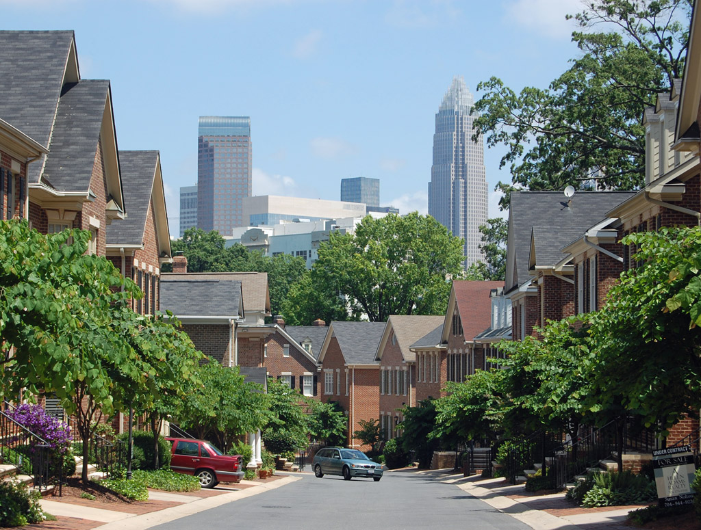
The green space here is private, not public
Cotswold's green space is mostly in its own back gardens: quarter-acre lots with mature hardwoods, which is the neighborhood's real amenity and the thing the rebuild market keeps testing. The public parks are a drive — Freedom Park and the Little Sugar Creek Greenway three and a half miles west, and Evergreen Nature Preserve, seventy-seven acres of hardwood off Central Avenue, to the northeast.
The resident's angle: the canopy on the unrebuilt streets is worth several degrees in July, and it is the first thing a teardown takes. When you compare two lots here, compare their trees — and check Briar Creek on the county floodplain layer while you are at it.
17 places, with real drive times
Road-adjusted distance and drive time from the centre of the community to each destination, nearest first. Filter by category.
Showing 1–12 of 17 places, nearest first.
Method: distances and drive times are computed from a representative point near Randolph Road and Sharon Amity, using straight-line distance multiplied by a road factor and a tiered speed model — honest ranges, not routed times. Cotswold's advantage does not show up in these numbers: nearly every trip on this page avoids both interstates, which makes the times less variable than the same distance elsewhere.
Every gym within reach
There is no municipal recreation centre in Cotswold. The free options are a drive: Freedom Park's loop three and a half miles west, and Evergreen Nature Preserve off Central Avenue. The commercial gyms are in the shopping centres on Randolph and Sharon Amity, and the nearest full-service pool and weight floor is the Dowd YMCA in Dilworth.
- Free, and the closest thing to an everyday outdoor facility for this neighborhood
- The Dowd YMCA in Dilworth is the nearest indoor pool and weight floor
- Commercial gyms and studios sit in the Randolph and Sharon Amity shopping centres
- The Little Sugar Creek Greenway runs beside Freedom Park for a longer paved route
| Facility | What it is | Drive |
|---|---|---|
| Freedom Park open | Ninety-eight acres with a loop, courts and fields three and a half miles west — the nearest large public park, and free. | 9–13 min |
| Dowd YMCA open | The nearest full-service YMCA is still the Dilworth one — Cotswold's own fitness provision is commercial and in the shopping centres. | 10–15 min |
The free option is Freedom Park or Evergreen, and both are a drive. Cotswold's trade is space at home rather than facilities nearby.
One school, two campuses, and a grade split
Billingsville-Cotswold IB Elementary has been a single school on two campuses since 2018: kindergarten to grade 2 at the Billingsville campus, grades 3 to 5 at Cotswold, with an International Baccalaureate programme at both. From there the usual path is Alexander Graham Middle and East Mecklenburg High on Monroe Road, though high school assignment varies by address on this side of Route 4.
| School | Board | Note |
|---|---|---|
| Billingsville-Cotswold IB Elementary School | CMS | Paired in 2018 into one school on two campuses — K–2 at Billingsville in the historically Black community west of here, grades 3–5 at Cotswold — with an International Baccalaureate programme at both. A deliberate integration measure and one of the district's most-studied. |
| Alexander Graham Middle School | CMS | The middle assignment for much of Cotswold, on Runnymede Lane between here and Myers Park. |
| East Mecklenburg High School | CMS | The comprehensive high school on Monroe Road serving much of the area inside Route 4 on this side. Assignment varies by address and some Cotswold blocks feed elsewhere. |
| Charlotte Country Day School | Independent | A large independent day school on Carmel Road, five miles southwest, drawing from this side of the city. |
| Central Piedmont Community College | Post-secondary | The main campus is on Elizabeth Avenue three miles northwest, with trades, nursing and university transfer programmes. |
The pairing was a deliberate integration measure and is one of the most-studied things CMS has done — worth reading about rather than guessing at. Check the address in the CMS assignment lookup, and note the district's magnet and assignment review, which is expected to change options from 2027.
Month by month, what living here looks like
Not a highlights reel — the actual annual rhythm, including the dates residents have to remember.
- Highs around 10 °C, and the neighborhood's tree cover is bare enough to see what a lot actually has
- The slowest month for listings; builders holding finished spec houses start to negotiate
- A ranch house's original single-pane windows are most obvious in January
- The wettest stretch of winter, and Briar Creek runs high through the neighborhood
- The best month to look at drainage and grading on a lot before the grass comes back
- Rezoning and teardown notices tend to appear on posts through the winter — worth reading
- Dogwoods and a Piedmont pollen count that coats everything
- Spring listing season starts and teardown lots trade quickly
- Freedom Park and the greenway fill up for the season
- Mid-20s and dry; the ranch-house streets with mature trees are at their best
- Peak competition for renovated houses and for lots
- School tours and IB information sessions run in the spring
- The canopy closes over the older streets; the newly rebuilt blocks stay noticeably hotter
- Humidity arrives at the end of the month
- End-of-year school events put traffic on Randolph and Sharon Amity
- Afternoon thunderstorms, and Briar Creek's stormwater is the neighborhood's recurring complaint about new construction
- Limb damage over 1950s roofs is an annual risk
- The oldest streets with intact canopy are several degrees cooler than the rebuilt blocks
- The hottest month; an unimproved 1950s ranch is expensive to cool and a rebuilt house is not
- Insulation, duct work and window age are the three questions to ask a seller
- The shopping centre and the pool are where the neighborhood spends the afternoon
- Schools return in late August and the two-campus school run makes Randolph busy twice
- The slowest month of the housing market and the best month to negotiate
- Hurricane season is under way even this far inland
- Hurricane remnants reach the Piedmont as rain and wind
- Briar Creek flooding is the risk to check for any low-lying parcel here
- Evenings cool into the low 20s and the trails refill
- Dry, mid-20s, and the best walking weather of the year
- Autumn listing season, smaller than spring but with less competition
- Peak colour comes in early November
- Quarter-acre lots with mature hardwoods mean a genuine amount of leaf work
- Listings thin and negotiation gets easier
- Thanksgiving quiets the neighborhood entirely
- The shopping centre carries the traffic; the residential streets are calm
- Highs around 12 °C — mild by any northern standard
- The last window to close before 1 January, which matters more than usual before the 2027 revaluation
20 photographs of Charlotte and the region
Drawn from the site's shared, freely licensed Charlotte photo library — not photographs of Cotswold itself. Filter by category.


Showing 1–12 of 20 photographs.
About these photographs. Openly licensed images geotagged in or near Cotswold, found on Wikimedia Commons and served from there with full attribution. Inline photos elsewhere on the page may still come from the site's shared Charlotte library.